October 3, 2011

Illustrated atlas of the afterlife

Filed under: Art,Design by Branko Collin @ 12:17 pm

Last year Guido Derksen, Martin van Mousch and Jop Mijwaard published a book about how different cultures and religions view the hereafter.

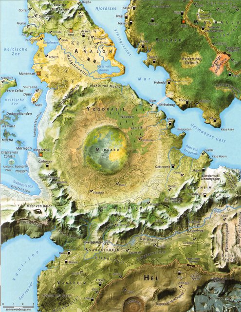
Rather than limiting themselves to a dry summing up of various theories, the authors actually made an illustrated atlas: eighteen drop dead gorgeous maps! There are maps of Dante’s hell, the Egyptian Duat, the Islamic, Jewish and Hindu heavens, and many more (shown here: Valhalla). The book drew positive reviews from both the religious and secular press.

Reformatorisch Dagblad (protestant) wrote:

The chapter about the medieaval folk tale of Cockaigne is a welcome change of tone, being comical in nature. The map contains a Tokkelroom Dale with a town called Advocaat. We also find a mountain range called Top Fermenting with a peak called Two Fingers. […] In conclusion it is an original, fascinating and informative book.

Holly Moors added:

To some people this may be a confrontational and sobering book, but it thought it was lovely. A piece of folkloric religion becomes pure literature again—back to the realm of Tolkien.

And VPRO radio: “Real maps […], so you’ll know exactly where you need to be.”

Moors has several samples of the maps, as does the authors’ blog, which discusses (in Dutch) how the maps were made.

De Geïllustreerde Atlas van het Hiernamaals, by Guido Derksen, Martin van Mousch and Jop Mijwaard, Nieuw Amsterdan, 2010.

Tags: , , , , , ,

February 26, 2011

Bad Google! Germans want their harbour back

Filed under: General,Online by Branko Collin @ 3:19 pm

The citizens of the port of Emden want their harbour back. A minor snafu with Google Maps makes it appear that the harbour belongs to the Netherlands, not to Germany, Sueddeutsche.de reports. The city has tried to rectify the error. Spokes person Eduard Dinkela told the paper: “Google is one of the largest communications platforms on the Internet, yet I do not seem to be able to reach them.”

Although everybody agrees that it is silly to suggest the border runs through Emden’s harbour, the actual position of the border is disputed, Radio Netherlands writes:

Historically, the exact location of the border was never properly settled between the Netherlands and Germany, although nobody has ever suggested that Emden’s harbour is actually Dutch. Germany says that the border runs through the Dollard estuary, close to and just below the Dutch dykes that line it. The Dutch claim the border runs down the middle of the estuary. The issue is theoretical rather than contentious.

Tags: , , , ,

November 7, 2009

Fantasy political map of the Netherlands

Filed under: General by Branko Collin @ 11:53 am

This map shows the fake island kingdom the Netherlands could be if its geography fully followed its politics. In the real world, top left dogs Nijmegen and Groningen are separated by 200 kilometres, as are right wing islands Kessel and Urk.

Here’s a quick legend: links = left, rechts = right, rood = red, rijk = rich, steden = cities, and midden = middle.

The two regions that in reality do exist as geographical areas are the Bible Belt and the Rode Regio, an area that used to have a lot of communists, basically the Groningen country-side.

The map is one of two made by Weetmeer.nl, the other following more classical coastlines.

I can vouch for the position of Nijmegen, having lived there for ten years. Nijmegen’s and Groningen’s progressive and left-wing attitude may at least in part have to do with a large student body, making up ten percent of the population in the case of Nijmegen. Would the Catholic church have thought that when they started their university there in the 1920s as a bulwark against socialist forces?

(Link: Geen commentaar.)

Tags: , , , , , ,