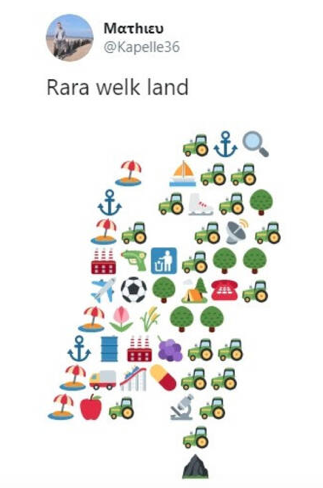
December 10, 2009

Low Countries map in shape of a lion

Filed under: Art by Branko Collin @ 9:02 am

Strangemaps talks a bit about this popular 16th century depiction of the Netherlands and Belgium as a lion, known as the Leo Belgicus:

The Leo Belgicus is a lion transposed on a map of the area, its ferocity symbolizing the belligerence of a nation fighting for its life. [...] In the 16th century, that general area was also known as the Seventeen Provinces, first under Burgundian and later Spanish tutelage. As the plural description suggests, these provinces were a loose confederation with little or no unifyingly ‘national’ sentiment.

That changed when religious upheavals pitted the increasingly protestant and independent-minded locals against their staunchly catholic Spanish overlords. The old Roman toponym Belgica was used to provide the entire Low Countries with a single geographic denominator.

The Austrian cartographer baron Michael Aitzinger, probably inspired by the prevalence of lions in the coats of arms of many of the Seventeen Provinces, drew the first Leo Belgicus in 1583, fifteen years into the Eighty Years’ War of the Spanish in the Netherlands. The long war soon became a stalemate, with neither party able to achieve total victory.

I remember the story being told slightly differently in history class, with emphasis being laid on Charles V being a good egg, on account of him being a local boy (born in Ghent), but his son Philip being a degenerate Spaniard with whom we wanted to have nothing to do.

(Link tip: Clogwog.)

Tags: , , , , ,

November 7, 2009

Fantasy political map of the Netherlands

Filed under: General by Branko Collin @ 11:53 am

This map shows the fake island kingdom the Netherlands could be if its geography fully followed its politics. In the real world, top left dogs Nijmegen and Groningen are separated by 200 kilometres, as are right wing islands Kessel and Urk.

Here’s a quick legend: links = left, rechts = right, rood = red, rijk = rich, steden = cities, and midden = middle.

The two regions that in reality do exist as geographical areas are the Bible Belt and the Rode Regio, an area that used to have a lot of communists, basically the Groningen country-side.

The map is one of two made by Weetmeer.nl, the other following more classical coastlines.

I can vouch for the position of Nijmegen, having lived there for ten years. Nijmegen’s and Groningen’s progressive and left-wing attitude may at least in part have to do with a large student body, making up ten percent of the population in the case of Nijmegen. Would the Catholic church have thought that when they started their university there in the 1920s as a bulwark against socialist forces?

(Link: Geen commentaar.)

Tags: , , , , , ,

September 11, 2009

New York birthday celebrations suffer heavy inflation

Filed under: General by Branko Collin @ 4:51 pm

new_amsterdamWrites the Washington Post:

Four hundredd years ago this month, Henry Hudson sailed on a Dutch ship into what became New York Harbor, a journey that inspired traders from the Netherlands to become the first immigrants to New York and establish a tolerant, motley Dutch settlement called New Amsterdam.

[...] While many New Yorkers are unaware of the festivities [...].

Times have changed since previous anniversary celebrations. In 1909, there were two weeks of events, forming what was then the biggest citywide celebration New York had seen with millions of participants.

In 1959, the current queen of the Netherlands, then Princess Beatrix, came to New York for the 350th anniversary of Hudson’s arrival, and celebrated with a ticker tape parade.

“The world then was a different world,” Dutch Ambassador Renée Jones-Bos said. “Now there are far more countries. You have to work harder as a country to show what you can do and raise your profile.”

(Image: Castello Plan of the tip of Manhattan.)

Tags: , , , ,

September 8, 2009

Rem Koolhaas condenses the country a bit further

Filed under: Architecture by Branko Collin @ 8:15 am

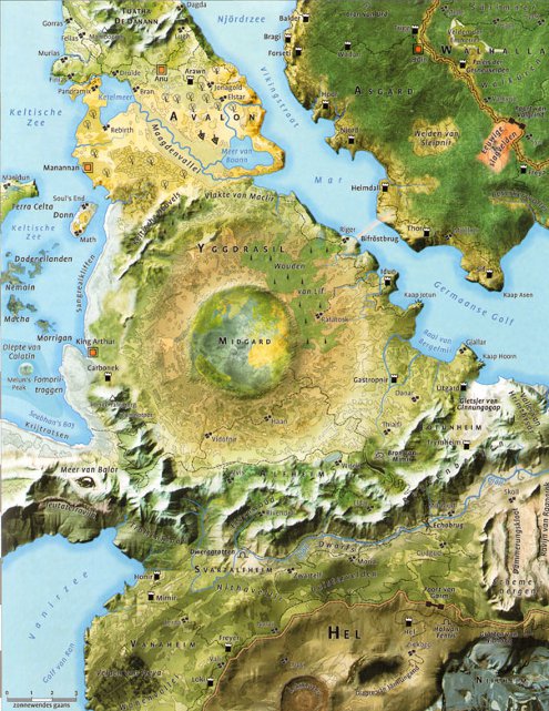
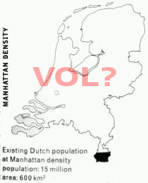
With 16 million people occupying a mere 14,526 square kilometres, the Netherlands is considered a densely populated country. For world-famous architect Rem Koolhaas that isn’t dense enough though. He imagined what the country would look like if the Dutch population density was that of Manhattan (shown here) or Los Angeles.

Strange maps doesn’t seem to mention where they got these images.

(Link tip: Tom Schuring. Image edited by me.)

Tags: , , , , , , ,

August 19, 2009

Biologist creates own ‘Streetview’ of Spitsbergen town

Filed under: Photography, Science by Branko Collin @ 7:59 am

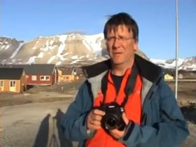
Biologist Maarten Loonen from Groningen figured that it might take a while before the Google Streetview cars and bikes venture deep within the Arctic circle.

His solution was to whip out the old camera and make his own “street view” of Ny-Ålesund, Spitsbergen. The round the clock daylight currently available there undoubtedly helped make the job easier. The result is a collection of 3,000 photos, according to Bright (Dutch), and a number of videos. Biologist Loonen took a picture every 10 metres inside the village and every 30 metres outside it.

Spitsbergen, meaning Craggy Island Mountains, has a Dutch name despite being Norwegian territory because it was ‘discovered’ by Dutch explorer Willem Barentsz. He was looking for the Northern passage to the East and died trying.

(Source photos: arcticstation.nl.)

Tags: , , ,

July 21, 2009

Vote for the next Google Street View target

Filed under: Bicycles, Dutch first by Branko Collin @ 9:16 am

Google has had a tricycle custom built to take photos in locations that Street View cars and vans have difficulty accessing. They already had the trike take pictures in Italy and the United Kingdom, and now it is heading to the Netherlands.

If you like, you can vote which Dutch locations will get the Street View treatment, candidates include the old Parliament buildings, the Efteling theme park, and the Scheveningen boulevard which sports the only pleasure pier of the country.

(Link: Algemeen Dagblad. Photo of an Efteling dragon by Jeroen Kransen, some rights reserved.)

Tags: , , , , , ,

Powered by WordPress