Low Countries map in shape of a lion
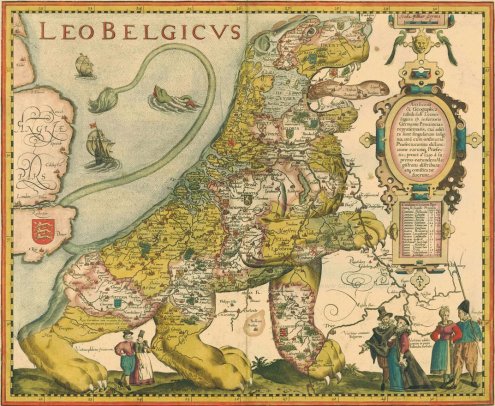
Strangemaps talks a bit about this popular 16th century depiction of the Netherlands and Belgium as a lion, known as the Leo Belgicus:
The Leo Belgicus is a lion transposed on a map of the area, its ferocity symbolizing the belligerence of a nation fighting for its life. […] In the 16th century, that general area was also known as the Seventeen Provinces, first under Burgundian and later Spanish tutelage. As the plural description suggests, these provinces were a loose confederation with little or no unifyingly ‘national’ sentiment.
That changed when religious upheavals pitted the increasingly protestant and independent-minded locals against their staunchly catholic Spanish overlords. The old Roman toponym Belgica was used to provide the entire Low Countries with a single geographic denominator.
The Austrian cartographer baron Michael Aitzinger, probably inspired by the prevalence of lions in the coats of arms of many of the Seventeen Provinces, drew the first Leo Belgicus in 1583, fifteen years into the Eighty Years’ War of the Spanish in the Netherlands. The long war soon became a stalemate, with neither party able to achieve total victory.
I remember the story being told slightly differently in history class, with emphasis being laid on Charles V being a good egg, on account of him being a local boy (born in Ghent), but his son Philip being a degenerate Spaniard with whom we wanted to have nothing to do.
(Link tip: Clogwog.)
Leave a Reply