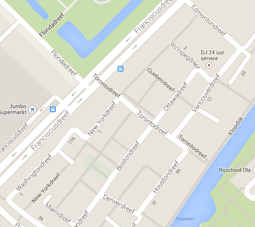
It hit me when I motored through the Overvecht neighbourhood of Utrecht that all the street names end in ‘dreef’ (roughly, ‘avenue’ or probably ‘drive’, [click on the image for a closer look], a bit of a 1970s trend someone once told me although I don’t know if that’s true.
Since I was heading to Manitobadreef and was curious as to why the street was named after a lesser known Canadian province, I wanted to know what other streets had Canadian names. Sure, there were tons more with American states (Texasdreef, Nevadadreef, Mississippidreef) and someone should check into those, but I couldn’t possibly imagine that Manitoba was the only Canadian one.
The Overvecht wikipedia page (Dutch only) tells me that there are street names from ‘America’, which means they are probably erroneously assuming that ‘America’ also covers Canada. Then they’ll say ‘we mean North America’ and then I’d retort ‘but you’ve missed Mexico’ [still a shocker at Dutch parties, Mexico is part of North America], as Mexicodreef was bundled with the South American and Central American names’. The article has some glimmer of self-awareness by stating that Australia has been completely ignored, so it could always be worse.
Back to the Canadian names per province:
- Manitobadreef
- Winnipegdreef
- Ontariodreef
- Ottawadreef
- Torontodreef
- Edmontondreef
- Vancouverdreef
- Quebecdreef
- Labradordreef
- Sint Laurensdreef
That’s two for Manitoba, the province and the capital. Nicely done.
Three for Ontario, the province, the nation’s capital and the province’s capital. Well done.
The capital of the province of Alberta is mentioned, but not Calgary, city of the 1988 Winter Olympics. Edmonton does have that huge mall.
The province of British Columbia was probably too long, the metropolis gets a mention, but no Victoria, the capital, which most people have to look up. But OK, everybody knows Vancouver, host of the 2010 Winter Olympics.
The province of Quebec gets a mention, but no Montréal though, home of the 1976 Summer Olympics. The capital is Quebec City, so this is good enough.
Labrador is part of the Canadian province of Newfoundland. A very odd choice, you’d think they went for the breed of dog.
I’m guessing it’s part of the river names they use in Overvecht for cross streets, so decent choice.
It’s still really hard to beat a neighbourhood named after Lord of the Rings characters.
 ‘Room for the River’ is a Dutch state project that intends to widen the floodplains of the major rivers.
 A special type of dredger used for mining sand in the Groote Wielen area of Den Bosch enabled amateur paleontologists Anton Verhagen and Dick Mol not only to add to their collection of bones, but also to keep track of the corresponding geological eras. The sand harvested by cutter-suction dredger Den Otter was to be used for building a new, nearby neighbourhood, and had to be scraped layer by layer in order to separate high-grade building sand from the rest. This method of dredging is slower, but because it separates out different types of sand early on, it’s apparently still cost-effective.
 Amsterdam is 200 years older than is commonly assumed, says historical geographer Chris de Bont. The settlement was originally started in 1000 AC instead of 1200 AC, which is still pretty young. De Bont bases his conclusion on the patterns formed by old brooks. “I found the same patterns elsewhere in the region where farmers lived around the time,” De Bont told print daily Metro, “so it’s logical to assume that farmers also created the patterns in Amsterdam.”