September 30, 2015

Dutch centuries-old bond keeps paying interest

Filed under: History by Branko Collin @ 3:43 pm

bond-lekdijk-bovendams

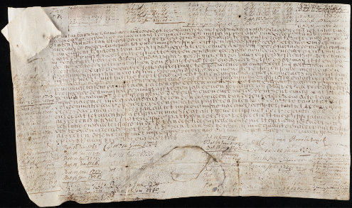
Two weeks ago Timothy Young, a librarian from Yale University in the USA, travelled to the Netherlands to collect 136 euro and 20 cents in interest from the water board De Stichtse Rijnlanden.

The interest was paid on a bond issued for 1,000 guilders in 1648 by the predecessor of the current board to fund the building of a groyne. At the time, the Netherlands was going through its Golden Age and the navigability of important trade routes like the main rivers was a priority (German link).

Interest on the bond must be collected at least once every generation, Yale News reports. The bond (issued by the water board of Lekdijk Bovendams) remains one of the oldest known living financial instruments in the world as long as interest is collected—the reason that Yale, which paid 24,000 euro for it in 2003 according to Bloomberg, is keen to collect those payments.

The document is a bearer bond, meaning the issuer needs to see it before paying out interest. The issuer will then write the payment date on the document. This would have provided a bit of a problem for Yale, because carting around a 367-year-old sheep skin across the airways might be detrimental to its health. Luckily, space on the bond proper already ran out in 1944 and in the same year an allonge was attached to it for keeping track of the payment dates. The water board allows the bearer to simply show the allonge.

The water board has records of five other bonds that still generate interest payments. The oldest of these was issued in 1624 for 1,200 guilders, also by the water board Lekdijk Bovendams. The same water board issued bonds for a total of 300,000 guilders in the first half of the 17th century after the 32-kilometre-long eponymous dike burst numerous times, the water board writes.

Water boards are a type of parallel local government that have been around since the Middle Ages. They take care of dikes and dams, among others, in a country of which 55% of the surface area is susceptible to flooding from either the sea or from rivers. Some of these boards belong to the oldest continuous governments in the Netherlands. The water board of Lekdijk Bovendams was founded in 1323 by the bishop of Utrecht and was later managed by the king, until 1971 when it was merged with a number of other water boards into the water board Kromme Rijn, which itself was later merged into the current water board De Stichtse Rijnlanden.

lekdijk-bovendams-e-dronkert

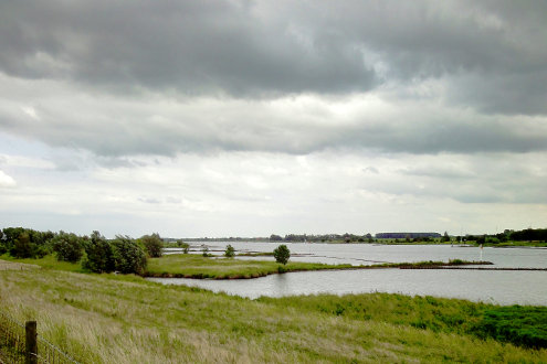
(Photo of groynes at the Bovendamse Lekdijk by E. Dronkert, some rights reserved; photo of the bond by Yale University)

Tags: , , , , , , , , , , , , , ,

January 17, 2015

Scientist predicts more river floods in the Netherlands

Filed under: Nature,Science by Branko Collin @ 7:33 pm

maas-near-steyl-martin-collin

University of Twente writes:

In the future, due to climate change and corresponding extremely high water levels, rivers in the Netherlands will be more likely to break their banks. This was the conclusion reached by Dutch researcher Suleyman Naqshband […]. River dunes in the major rivers of the Netherlands tend to persist and not flatten out, thereby increasing the risk of flooding.

River dunes in this case is the somewhat unfortunate name for sand structures at the bottom of the river. Apparently they are quite common in Dutch rivers. The university adds:

These river dunes can reach large sizes, growing to as much as one third of the total water depth. This restricts the flow of water, causing water levels in the area of river dunes to be much higher than in sections of the river in which they are absent. River dunes are also dynamic, growing rapidly in just a few days then flattening out or even disappearing completely at extremely high flow rates.

(Photo of the river Meuse overflowing in 1980: Martin Collin)

Tags: , , , , ,

September 20, 2014

The Delta Works are due for an upgrade

Filed under: General by Orangemaster @ 8:01 am

Delta works

Last Tuesday the Netherlands unveiled a multi-billion-euro, multi-decade plan to counter the biggest environmental threat to the nation: surging seawater caused by global climate change.

For centuries, the Dutch have battled the waters of the North Sea that have at times flooded large swathes of the country, particularly in its southwestern Zeeland province. After a disastrous flood in 1953 which left almost 2,000 people dead in Zeeland, the Dutch built a system of dams, storm surge barriers, dykes and other water-management projects, known collectively as the Delta Works, to keep the sea out.

But a growing population, growing industry and climate change have necessitated a ‘new Delta plan,’ Schultz van Haegen said as she unveiled the details in The Hague. A study by the Dutch National Environmental and Living Institute, released last week, showed one in three dykes or dams did not comply with current safety standards.

Wikipedia tells us that the Delta Works have been declared one of the Seven Wonders of the Modern World by American Society of Civil Engineers.

See also Dutch dike protects national archives in Washington.

(Link: phys.org, Photo of Delta Works by Coanri/Rita, some rights reserved)

Tags: , , , ,

February 18, 2013

How to build bigger floodplains

Filed under: Nature,Sustainability by Branko Collin @ 1:08 pm

‘Room for the River’ is a Dutch state project that intends to widen the floodplains of the major rivers.

The project does something that is quite rare for the Dutch, it gives land back to the water. In 1993 and 1995 we had major river floods, the latter even leading to the evacuation of 250,000 people. Geographically, the Netherlands is a river delta, and the Dutch have always had to live with river floods. However, today the population pressure has made the consequences of floods much more expensive.

As the project website says: “The rivers are wedged between increasingly higher dikes behind which more and more people live. At the same time, the land behind the dikes has sunk. It is also raining more often and harder, causing rivers to swell. Water levels are rising and so is the chance of floods with a large impact on people, animals, infrastructure and the economy.”

The New York Times has visited one of those projects and uses it for an opinion piece on how big government is good.

Short read: The Ruimte voor de Rivier site has Nine easy infographics on how to give the river room.

(Photo: Waal beach by Rijkswaterstaat / Ruimte voor de Rivier / Martin van Lokven)

Tags: , , , , , , , , , , ,

July 11, 2012

The Netherlands grows itself a bit further

Filed under: Architecture,History by Branko Collin @ 10:53 am

Tweede Maasvlakte indicated with a dotted line. The white blotches to the North-East are caused by sunlight reflecting off the greenhouses of the Westland area.

Today Queen Beatrix will officially close the last bit of an 11 kilometre dam that encloses an area of the North Sea that should become new land this year.

The Tweede Maasvlakte will be a 2,000 hectares large area atttached to the first Maasvlakte (‘tweede’ means ‘second’) outside Rotterdam that will be used as part of the port. The Betuwelijn railroad will be extended into it. It will mainly be used as a container harbour.

The new land will grow the area of the harbour by 20%. The dam surrounding Tweede Maasvlakte will contain 20,000 blocks of stone. RTV Rijnmond calls it an ‘ultra-Dutch project’, as it involves ‘building land to trade upon’.

To my knowledge there are no plans yet to extend this thing all the way to England, though people have been talking about moving our national airport to the sea.

(Image: NASA + 24 Oranges)

Tags: , , , , ,

May 15, 2010

Angry citizens remove ‘illegal’ dam

Filed under: Architecture,Nature by Branko Collin @ 2:01 pm

Last week inhabitants of the Horstermeer polder just south of Amsterdam removed a 10 ton weir placed there by the AGV water board (Amstel, Gooi and Vecht regions). They claim the dam creates a dangerous situation.

The water board wants to let nature run its course in a part of the polder by letting water levels rise, effectively turning part of the polder into marshland. The inhabitants fear that since their houses are typically located at the lowest point of the polder, the centre, these higher water levels will damage their properties.

According to the polder dwellers, the water board never filed official plans for their dam, so that the inhabitants could not legally protest its placement. The water board has reported the theft of a weir to the police.

Water boards are a parallel government in the Netherlands for the management of water.

Video: Republiek Horstermeerpolder.

Tags: , , , , , , ,

August 10, 2009

Floating apartment building in Westland

Filed under: Architecture by Branko Collin @ 9:31 am

citadel_waterstudio

This floating apartment building called Citadel was designed by Waterstudio architects of Rijswijk and will be built in the Nieuwe Water area of the Westland region, West of Rotterdam a municipality in the Western Netherlands.

Westland is mostly known for its greenhouses (see a Google satellite image and you will know what I mean). The Nieuwe Water area (Dutch) is a low point in this polder and therefore suffers minor floodings every time there are heavy rains. New trends in water management have led to the belief that it is good to make room for water, and that is what is being done here.

The Nieuwe Water area West of the town of Naaldwijk, traditionally full of greenhouses, will be flooded artificially, after which houses will be built in it that somehow will have to be able to deal with the fact that the water level can rise up to 36 centimetres, stowing 75 million litres of excess water. Another housing solution by Waterstudio for this area are these stilt houses. The Citadel will have 60 apartments.

Construction of Het Nieuwe Water will start this year.

Update: Orangemaster tells me she translated a good book that can give our readers further insights about the new ways of Dutch water management called Atlas of Dutch Water Cities. A San Franciscan bookstore summarizes it as follows:

Illustrates the relationship between urban development and water engineering, and portrays a vast number of projects integrating the infrastructure of waterways and flood deferences in architectural concepts.

(Source photo: Waterstudio. Link: Trendhunter)

Tags: , ,